Now where was I when we left off last? OK, I remember, we were going to Fort Louisbourg tomorrow. Easy, I can catch up. (Sorry about some of the time lags, but with being on vacation and all, I didn't think I had a timetable!!)
We were originally going to drive around the Cape Breton Highlands National Park today (clockwise), but after checking the weather (cloudy & rainy) we decided to go to the Fortress of Fort Louisbourg National Historic Site instead. Also, some of our fellow house guests (the Irish couple Vicki wrote about) told us that the Fort was really worth visiting.
The largest reconstructed 18th-century French fortified town in North America, it was really amazing. Louisbourg was originally founded in 1713 by the French as a fishing outpost in the America’s. Remember that the French were Catholics and they ate a lot of fish that needed to be provided. Well, not only did Louisbourg provide for their own population with fish, but they smoked and salted and shipped fish back to France. Developed over several decades, by 1744 Louisbourg was a thriving seaport and capital of Île Royale (Cape Breton Island).

 In the 1960’s a concerted effort was begun and it took 12 years to reconstruct what is currently standing, which is only about a fifth the size of the original Fortress. We started off with a 75 minute introduction tour which ended up being close to 2 hours. The guide was very well informed, and a native of the town of Louisbourg with roots back to a French sergeant who decided to stay after the British took control. After the tour, we wandered around the grounds and buildings.
 |
| This is the town, not the Fort |
About a 90 minute drive (no metric conversions to worry about when dealing with time) from St. Ann’s, and on the far side of the Island, near Sydney, we ran into sun and the Fort. We drove to the guard’s gate and are told to park in Lot 1. And after first passing Lots 5-2, we are again glad that this is September, and the kids are back in school. We first go to the Visitor’s Center, and can’t see the Fort when arriving; we pay our entry fee, and quickly exit the building to the bus that will take us to the Fort. Through the woods, and then out into the open and across a rubble causeway, and there it is. Not a Fort, but a FORTRESS!
 |
| Current reconstructed area is only about one fifth of original site! |

The Fortress of Louisbourg was one of the busiest harbours in North America and one of France's key centres of trade and military strength in the New World. Then came the war between France and Britain, mostly fought in Europe, but the threat of British invasion during this turbulent time of empire-building, Louisbourg was continually fortified, and besieged twice before finally being destroyed in the 1760s. Both sieges by the British came from the land side of the Fortress, but the French didn’t seem to believe that any successful attack would be launched that way and they put all of their effort in defending the approaches by water (even to the point of leaving all their cannons in place where the landside defenses would have been). Well, the British landed about 6 miles down the coast, marched and dragged their army and artillery through the back-country, and made two successful attacks on the French by turning the French cannons around and using them against the French. Finally the British ordered the Fortress dismantled and destroyed, and that is the way it remained until the 1940’s when archaeologists began to reconstruct the fortress as it was in the 18th century.
 In the 1960’s a concerted effort was begun and it took 12 years to reconstruct what is currently standing, which is only about a fifth the size of the original Fortress. We started off with a 75 minute introduction tour which ended up being close to 2 hours. The guide was very well informed, and a native of the town of Louisbourg with roots back to a French sergeant who decided to stay after the British took control. After the tour, we wandered around the grounds and buildings.
There were interpreters in many of the buildings in period costume who were ready to answer all questions as they would have been answered in the 1750s. There were also cutaways in some of the buildings showing how the buildings were constructed from the foundation up, including doors, windows, wall coverings, and stairs. I was amazed at how much detail there was in the 1700’s, and except for the types of tools used to fabricate the different parts, the basic designs and building methods were the same. Both Vicki and I thoroughly enjoyed our time in the Fortress, and also gained even more insight into the Maritime Provinces’ history.
Now back to the west side of the island and Port Hood for tomorrow’s trip up to and around the Cape Breton Highlands National Park (clockwise), and then back to Whycocomaugh on the Bras D’Or Lake. We wake up to a cloudy morning, and are a little bummed out, but, like many of the mornings so far, by 10am the sun is out and the day is looking to be beautiful. I will warn you now, I won’t be writing a great deal about today – not because it isn’t worthy, but because I probably am not worthy to express in writing the sheer magnitude of the beauty that we saw. We started by back tracking the route of two days ago – Port Hood (on the coast), Mabou (inland),Inverness (back on the coast),
We're back in the car and, finally, back on the coast and we go through Point Cross and Cheticamp, and are beginning to see what we have been told we will see. But not until we enter the Park proper, do we really see the beauty. Lush highlands, sheer cliffs, and blue, blue water; beautifully green and lush valleys and breathtaking coastal vistas – all visible by turning only 90 degrees while standing in the same spot.
 |
| Road signs are in English & Gaelic in this Scottish region of the Cape |
and then through the Margaree Valley and several of the Margaree towns – South West Margaree, Margaree Centre, Margaree Forks, North East Margaree, Margaree, and Margaree Harbor – Margaree must have been something (no history here, I was afraid to look her up). However, the Margaree River is world famous for it’s Atlantic Salmon fly fishing and that while we were in the Valley and in one of the towns (none of which were bigger than our own West Bloomfield) we discovered a cutting board factory using Larch wood. [Larch (Larix) is one of only six deciduous (lose their leaves – like maples, elms, oaks), coniferous (cone bearing with needles or flat scales – like spruce, pines, firs) trees in the world.] Well, it just so happens that Larch wood is noted for its rot resistance, strength and ability to neutralize bacteria which gives it all of the characteristics to produce a superior cutting surface. Plus, it’s grain pattern and natural coloring make it a beautiful as well as practical cutting board. The manufacturing process was pretty straight forward and pretty much like any other end-grain visible, glued-up butcher block, but the finished product was really something.
 |
| Road signs are in English & French in this Acadian region of the Cape |
We're back in the car and, finally, back on the coast and we go through Point Cross and Cheticamp, and are beginning to see what we have been told we will see. But not until we enter the Park proper, do we really see the beauty. Lush highlands, sheer cliffs, and blue, blue water; beautifully green and lush valleys and breathtaking coastal vistas – all visible by turning only 90 degrees while standing in the same spot.

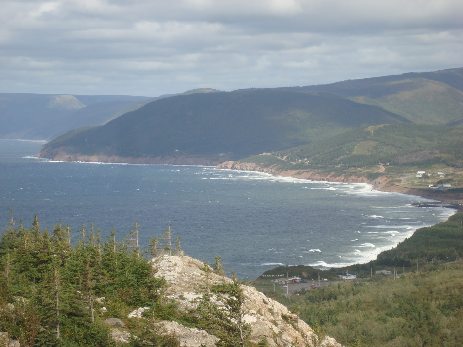
 The Cape Breton Plateau is part of the worn down Appalachian mountain chain which stretches from Georgia to Newfoundland consisting of steep cliffs and deep river canyons carved into a forested plateau bordering the Atlantic Ocean. You have to see it for yourself to really appreciate it. From Pleasant Bay to Neals Harbor is all inland across those rolling hills, deep river canyons and lush vegetation.
We stopped at Neils Harbor at the Chowder House (one of the many by the same name, but nothing else in common) and had another great meal of clam chowder, seafood chowder, and fish and chips, and great pie alamode, and sweet iced tea. (Everywhere in Canada serves sweet iced tea, which really makes sense since sugar doesn’t desolve well in cold tea.)
 Plus, Neils Harbor is a very pictuesque and quaint fishing village. Again on the road, we pass through Ingonish and Ingonish Beach and are now out of the Park, but not without many more spectacular coastal and inland valley vistas. It’s getting late now and we pass through St. Anns and Baddeck before we arrive in Whycocomaugh for a good nights rest.
Last night we ate at a local greasy spoon in Whycocomaugh, and I had really good fish cakes, with really good chow. Was going to have the apple crumble but Vicki said no! But I tried again in the morning and had a good breakfast, but Vicki said no to the apple crumble, also again. So, with a frown on my face, we are on our way to Prince Edward Island via Pictou, Nova Scotia. Well, the Canso Causeway was not nearly as much fun as when we went over it after Hurricane Igor. We drove over the causeway and onto Pictou, Nova Scotia, for our ferry ride across the Northumberland Straights of the Gulf of St. Lawrence to Woods Island, Prince Edward Island (PEI).

Leaving Pictou to catch the ferry at nearby Caribou, I got lost. The GPS didn’t know where we were except that we were driving somewhat parallel to the correct route. I asked a man on the street, and his directions almost got me more lost, until Vicki saw a sign directing us to the ferry terminal. WHEW! We arrived at the ferry just as it was arriving from PEI, and within 20 minutes we were loading. We grabbed a bottle of wine, cheese and crackers, fresh cookies, an apple, the computer and a couple of books and headed for the top deck where we were rewarded with window seats, nice comfortable seats and a table. I finished writing about Mabou and didn’t write anymore for the rest of the trip.
 |
| Loading the ferry and leaving Nova Scotia |
 |
| Arriving Prince Edward Island |
The ferry ride was just like the St. John to Digby ferry, except less expensive. [We found out that you pay only when you leave PEI, and there are only two ways to get on or off the island – the ferry or the bridge. Without knowing it, we planned our trip leaving on the cheapest route of egress, the bridge, by $20.] Arriving in PEI – Woods Island – we exited the ferry, and drove to our next way point, Cornwall, just outside of Charlottetown. We’re tired, and go to bed early, with breakfast scheduled for 8am.
No comments:
Post a Comment